|
|
This month we are taking a break from normal and featuring a trail that was the site of our last Trail Maintenance outing of the season. As described, it also includes trails that were worked on in March as part of a special work-day event with REI.
There are a number of different ways to get to the Forest Trail in Malibu Creek State Park - from the east at the main park entrance, from the west via Reagan Ranch at Cornell and Mulholland, or from the north where the Cistern and Lookout Trails cross Mulholland. Any of these would be enjoyable and each has its own charm. It is advised to consult a map and if possible, bring it with you. This month's Trail of the Month describes the approach from the north.
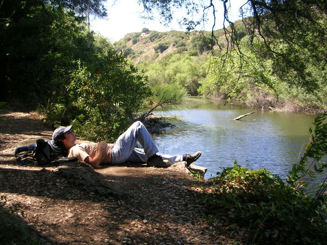
While quite hot on a July afternoon, (bring lots of water!), there was considerable shade on these trails. The Forest Trail itself is mostly shaded courtesy of some coast redwoods, and makes for a perfect picnic spot next to Century Lake.
The trailhead to begin our journey is the Cistern Trail, which meets Mulholland Highway 1.7 miles west of Las Virgenes Road, or 1.4 miles east of Cornell Road. There are a couple of utility boxes and ample parking at the trailhead. Elevation here is about 1020 feet; our destination at Century Lake is around 650 feet, so be prepared for more uphill on the way out.
Cistern Trail ascends a bit as it leaves Mulholland Highway, but soon after begins heading downhill, with views of Reagan Ranch off to the right, and the Goat Buttes and Castro Crest of Malibu Creek State Park ahead of you. Plants I noted on this stretch of trail included sage, buckwheat, thistle, pearly everlasting, bush mallow, woolly blue curls, fringed indian pink, matilija poppy, and plummer's mariposa lily. Also noteworthy are the numerous erosion control features added to the trail on the REI workday of this past March. They are doing their job in keeping water from eroding the trail.
At about a quarter-mile in you will descend some steps - keep an eye out at the bottom for an intersection with Lookout Trail. On the return trip we'll come from the right and retrace the steps we've made so far; for now though, stay straight to continue heading towards the lake. There is a spur trail to the right a few steps further, which can be ignored also. Continue descending, through ceanothus, sumac and deerweed. Indian paintbrush adds a splash of color, and soon you get your first glimpses of the lake that is our destination. Shortly thereafter, you can look left and see the Visitor Center and bridge in Malibu Creek State Park. Saddle Peak looms high further to the east. A little further there is a clearing with a nice view of the lake - a good spot to take a break. See how many redwoods you can count. Note Crags Road below you; you will reach it in about a tenth of a mile. Foothill penstemon and monkey flower dot the path on your way, along with a few more drains courtesy of the REI workday.
At Crags Road, turn right. Unless you are looking for an extra diversion, stay straight at the junction about 100 feet ahead - the trail to the left goes to the near side of the lake.
About a quarter mile from where Lookout Trail deposited you onto Crags Road is a junction with Cage Creek Trail - the sign is set back from the road a few feet. The route as described here will take you that way on the return. For now, continue on; you will shortly reach a bridge. This is 1 mile in from the road.
After lingering a moment to listen to the sounds of rushing water, hang a left 50 paces after the bridge. You are now on Forest Trail, though as of this writing there is no sign there to tell you so. Immediately you will cross a dry creekbed, followed by a short stroll through a meadow, to arrive at the edge of a shaded section where you will step over a fallen oak. From here on, it is mostly shade. Be on the lookout for poison oak (leaves of three...) - while June's trail maintenance outing cut it back considerably, it is still present on the edges of the trail. Other plants you will encounter on this trail include bay trees, oaks, ferns, mugwort, periwinkle, and as mentioned earlier, coast redwoods.
At a third-mile from the bridge, the trail opens up and forms a bank next to the lake. If you brought a picnic lunch, this is the place to eat it. While the water is greenish, there are fish in it. A bullfrog off to your left may sing for you. Cattails sway in the breeze on the other side.
When you've awoken from your post-lunch nap, walk on to where the trail ends at a dam. Directly across is where that other lake-trail from Crags Road would deposit you. Do NOT cross. Instead, retrace your steps up the shaded forest path back to the bridge to listen to the rushing water one more time, then about 600 feet more to Cage Creek Trail, which will be on your left.
Cross a creekbed and back again, and ascend through a wooded area. See heart-leaved penstemon, elegant clarkia and morning glory. Admire the rock-work done as a bonus to our Forest Trail June maintenance. Drink more water, take a breather when you need it - remember, it is mostly uphill on the way back.
At about a third of a mile from the bridge, and two-thirds mile to your car, you will emerge into a field and reach a junction. The trail to the left would take you to Reagan Ranch. Head right instead. You'll see your car on the road in a bit. You may encounter some wide-throat monkey flower along the trail after it reaches shelter again. In about a half mile, you are back at the junction of Lookout and Cistern Trails. Turn left, and you're soon (longer on a really hot day) back to your car.
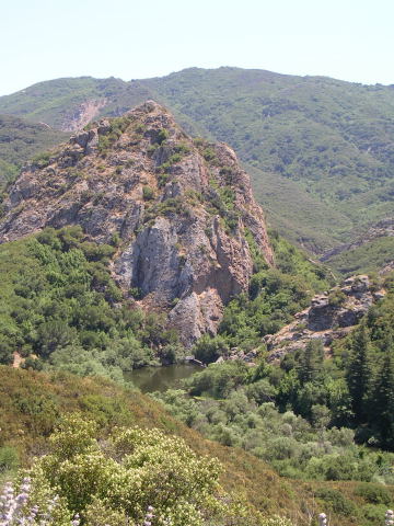
Century Lake and Goat Buttes from Lookout Trail |
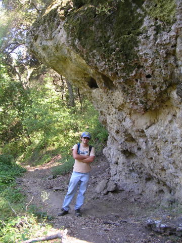
Natural features along Forest Trail |
Contributed by Liz Baumann.