Selected Hikes from Milt McAuley
Zuma Ridge
(Shuttle)
The following is reprinted by permission of the author, Milt McAuley. You can discover more hikes like this in his books on the Santa Monica Mountains. Milt passed away in 2008 but his impact lives on! Remember to always: contact park agency for area specifics, practice the "buddy system", consult a map, wear appropriate clothing, take extra water, and don't disturb or remove anything. Did we mention, Enjoy Yourself!
Maps: SMMTS, Central Section
Distance: 6 miles, one way
Elevation: 800' gain, 2100' loss
Terrain: Fireroad and trail
Time: 3-1/2 hours on the trail
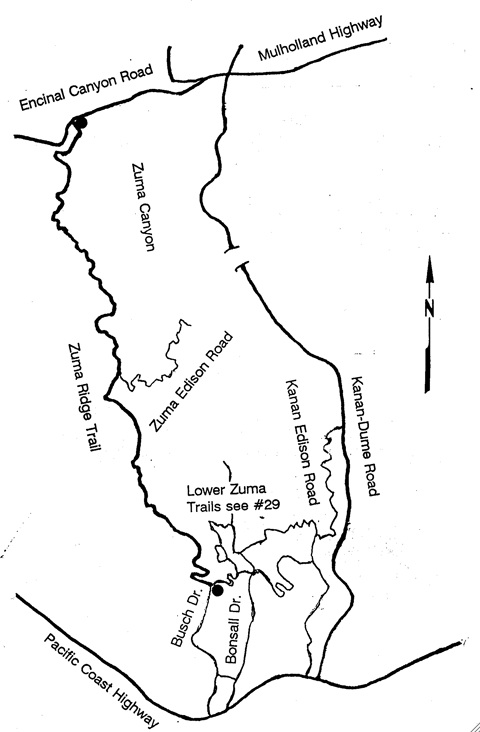
Trailhead: Ending: Busch Drive
Beginning: Encinal Cyn Rd
We set up a car shuttle by driving the Pacific Coast Highway going west of Point Dume and turn inland on Busch Drive. Go to the end and park. This will be the end of the hike. Drive all hikers east on PCH, turn left on Kanan Dume Road, north to Mulholland and turn left. Go nine-tenths of a mile and turn left on Encinal Canyon Road to drive 2-to-3 miles to park alongside the road. This hike is described as a north to south one-way shuttle. Besides hikers we expect equestrians and bicyclists. If it weren't for the long initial uphill grind, a bicycle might be preferred because the trail is actually a well maintained road that flattens out along the ridge.
Zuma Ridge Trail (a dirt road) begins west of the water recycling pool and goes south. For the first quarter mile the climb is a gentle uphill then a slight dip, and here is where the Backbone Trail comes in from Kanan Road. The trail becomes steeper and the next mile gives us a 700' gain. We reach our high point of the hike in about 45 minutes of steady walking, then we begin to lose altitude for the rest of the trip. We do have some ridge knolls to go over but nothing serious. Near the high point Buzzard's Roost Ranch forks left. This is a private road so we continue on the Ridge Trail.
After passing the Buzzard's Roost Ranch junction we can look west and see Trancas because the canyon walls are steep and out of our sight. About one hour and twenty minutes after we started the hike, and after a down-ridge elevation drop of 600' in altitude Zuma Canyon begins to come into full view. I consider this canyon, viewed from this spot to be among the spectacular sights in the Santa Monica Mountains. Although we won't descend into this part of Zuma, a trail does go to the stream and up a trail on the east slope. If you are inclined to do this some other time look for the power lines overhead over the trail. Then a fork on the left will take you 1100' to Zuma Creek. At this point on Zuma Ridge Trail we are almost three and a half miles into our walk, with about two and a half miles to go.
We have been high on a ridge, and with good visibility should identify off shore islands and some features of the coast line. Point Dume is ahead of us and as we approach the end of the hike we can see our cars.
P.O. BOX 345
Agoura Hills, CA 91376
Email: mail@smmtc.org
Phone: 805-885-7224
SMMTC is a volunteer, tax deductible,nonprofit 501(c)(3) charitable organization
Tax ID: 95-3911604